Blog

Freezing Drizzle AND Snow?

You may wonder, “How can it snow & drizzle at the same time?”

Short answer: when clouds aren’t cold enough to produce snow (exclusively or at all) drizzle can form.

Longer answer: If the air is sufficiently cold and wet, only snowfall is possible. But when precipitating cloud top temperatures are above -10° C (14° F) but still below freezing, the ice nucleation process requires help. Unstable, rising air can induce the formation of snowfall. Failing that, with only slightly below freezing temperatures, snow crystallization needs smoke, dust, pollution or any other tiny airborne surface upon which to bond. Otherwise precipitation can fall as drizzle/mist.

Why today? We’ve had a shallow layer of moist, sub-freezing air (< 5,000 ft) “capped” by warmer, drier air above since Sunday evening (1/26/20). Cloud tops have been just below -10° C. The moist air from sublimating snow/ice and weak low pressure has combined with onshore, upslope winds to induce some lift in the lower atmosphere. This, along with whatever particulates were aloft, produced snowfall. The remaining moisture has fallen as drizzle which froze upon contact depending on the surface composition. Most surfaces weren’t cold enough to allow much, if any, ice accumulation. A light glaze has been observed in places around our property — just enough to increase stopping distances on untreated pavement.

Normally this time of year clouds are much colder. But we have been running well above normal throughout the atmosphere recently. That’s why we’ve had several wet snow events in December & January.

Revising Alert Policy

I normally don’t allow “Winter Weather Advisories” (WWA) to post on the City page (home page), because too often those end with unremarkable snow totals here. Also, people tune out after a certain point if they are constantly barraged with alerts, which can happen during the winter here.  When you see an alert posted on our main page, you can generally place confidence in its importance and relevance to the city.  Note that the detailed forecast will always specify accumulating precipitation within the next couple days regardless of alert status.

When I saw the Winter Weather Advisory hoisted on Friday (1/17/20), I decided to post it. I could see that just the front-end of the incoming storm was forecast to deliver 4-7″ in about 12 hours. I could also see that conditions were right for a decent amount of lake effect over the following 24 hours.  The $64,000 question, as always, was “how much?”

Continue reading “Revising Alert Policy”

Live Blog (January 18-20, 2020)

  • 1/20 08:00 AM:
    Skies are finally clear. The moon is up in the SE sky. Snowfall has ceased! Picked up an additional 0.2″ overnight to bring our final storm total to 11.3″.
  • 1/19 10:15 PM:
    The dry air that was supposed to enter the area by midday never happened. Instead, we’ve seen a steady stream of light, lake-effect snow. 0.4″ has fallen today and continues falling at this hour. This brings our storm total to 11.1″.
  • 1/19 2:50 PM:
    Light, intermittent snow showers continue coming in off Lake Superior, but, so far, it hasn’t been accumulating. The weekend storm total remains 10.7″ since Friday night (1/17). If you’re thinking of waiting until the holiday tomorrow to clear snow, that’s not a bad plan. Winds will be lighter, and the sun should come out.
  • 1/19 11:00 AM:
    Only a trace of additional snow since 7:30 AM. Snowfall is now intermittent with peaks of blue skies and sunshine. Looks like the storm is finally wrapping up.
  • 1/19 10:00 AM:
    Seeing some localized blowing snow. Gusts have been around 20 mph this morning.
  • 1/19 7:45 AM:
    2.4″ of fresh snow fell between 11:15 PM last night and 7:30 AM. Storm total is now up to 10.7″. Light to moderate snowfall continues this morning. Snow should end by noon but winds will remain brisk.
  • 1/18 11:30 PM:
    Another 1″ of snow has fallen in the last 3 hours bringing our storm total to 8.3″. Models show another 1″ mostly falling before daybreak. Wouldn’t be surprised if that turns into 2+” by 8 AM.
  • 1/18 8:20 PM:
    We picked up 1.3″ of additional snowfall from 2 PM to 8 PM. Event total so far: 7.3″. Meanwhile, lake-effect snow showers are underway and should intensify as the night wears on. I’ll take one more measurement before midnight.
  • 1/18 4:40 PM:
    Pressure is now rising. Winds directions are wobbling from north to northwest. Winds should stabilize to northerly eventually. There may be a bit of a lull for a few hours while lake-effect snowfall conditions optimize (faster winds, cooler temps, etc). Next snow measurement: 8 PM.
  • 1/18 2:15 PM:
    Additional 0.6″ measured at 2:00 PM bringing storm total to 6.0″. Expecting pressure to bottom out in the next couple hours. Winds will turn to the north and increase in speed as lake-effect snow commences. Could see heavy snowfall again this evening and/or overnight.
  • 1/18 12:10 PM:
    Snuck outside at noon for a preliminary measurement following heavy snowfall. Recorded an additional 3.7″ since 8 AM. That brings the storm total to 5.4″.
  • 1/18 10:35 AM:
    A heavy band of snowfall has dropped visibility to 1/4 mile. Meanwhile, wind speeds have been trending down all morning. Expect a directional change this afternoon. That’s when Lake Superior starts to get involved.
  • 1/18 8:00 AM:
    1.7″ measured since snow started flying last night. It’s fairly lightweight & shouldn’t be too difficult to shovel. I’ll take another measurement at 2 PM.

Weekend Wrap Up (1/10-12)

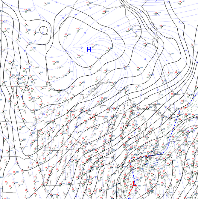
Surface map at 2 PM Saturday 1/11/2020 courtesy of College of Dupage

Some may wonder what happened to all the snow that was in last week’s forecasts. Well… this is a story about a cool, dry Canadian high picking a fight with a warm, moist low to the south.

Numerical weather predictions (“the models”) were all over the place in the days leading up to the presumed storm Saturday/Sunday. In the end, the low pressure system with all the embedded moisture ended up tracking further southeast into Lower Michigan. High pressure won the day.

However, northeast winds and cooler temperatures were sufficient to produce some extremely lightweight, low-intensity, lake-effect snowfall. This is snow where you can decide between a shovel and a broom when it comes time to clean up! Gusty winds kept lifting it off our snow boards. We ended up only measuring 0.2″. But our estimate is about 1.5″ of snow fell early Saturday through Sunday afternoon.

An active week to 10 days lies ahead. In particular, a significant storm originating out of the Rockies may head up our way Fri/Sat. Some smaller snow events in between. Also some lake effect to follow, possibly.

Back to Top
Theme:

(Auto night: 10:03 PM - 5:31 AM)