Blog

New Hourly Forecast Feature

hourly forecast as seen on iPhone
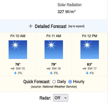
As of today, an hourly forecast from the National Weather Service is now available on the home page. Simply locate the horizontal row of weather icons and look immediately beneath them. You will see a section header: “Quick Forecast”. There you can select either “daily” or “hourly”. Your device should remember your selection over time (assuming you haven’t disabled “cookies”).

This new feature will allow you to see the next 24 hours in terms of temperature, wind, sky conditions and probability of precipitation. You can easily scroll with a finger (mobile) or trackpad (laptop) to see all available hours.

Also, for our “power” users, if you visit page settings on the home page (see gear icon in upper right), there is an option to enable dewpoints on the hourly forecast. This is quite useful in the summer to determine how “muggy” any given day will feel. The general rule of thumb is it starts to feel humid when dewpoints rise to the low 60s or greater. Once it hits 70° (only maybe a few times per summer in Marquette, generally), it’s quite humid. In the winter, when the dewpoint and the temperature begin converging, the likelihood of snow goes up. So there is value to this reading year round.

We hope you enjoy this new feature. Let us know what you think in the comments below.

Site to Enter “Night Mode” at Sunset

In an effort to ease your pupils and preserve your circadian rhythms, this website now features dark background colors with light text from sunset to sunrise.

If you’re unfamiliar with this trend in web and application design, I encourage you to enter “blue light sleep” into your favorite search engine. Also, going “dark” at night saves energy since screen light accounts for a large percentage of power draw on any computing device.

Our design aesthetic (while certainly not “modern”) has long featured natural environmental cues. Night mode provides yet another indication of what is happening in our community. People from other time zones who visit the site (and we get a number of them daily) will now immediately know whether it is night or day here.

Currently, I am working on a user override feature for those who don’t enjoy this style change. I hope to release that enhancement within the next several days.

In the meantime, let me know what you think in the comments below.

****

UPDATE 8/11/22 7:45 PM:

Theme options (auto | day | night) now appear at the bottom of each page. The site defaults to “auto” which will enable night mode only at night. But you can choose to override with “day” or “night” mode at any time. A cookie will be saved on your device so you shouldn’t have to continually select your preferred option each time you visit.

UPDATE 9/15/22 7:15 AM:

The site will now enter night mode at nautical sunset and remain dark until nautical sunrise. This will ensure it is actually dark outside when the site is in night mode. For more information on those times in Marquette, see https://www.timeanddate.com/worldclock/usa/marquette.

UPDATE 9/17/22 3:00 PM:

The nautical sunrise/sunset times are now listed at the bottom of each page.

Winter Storm Wrap-up (2/21/22 – 2/23/22)

After 50+ hours of snowfall, the sun finally appeared this afternoon!

This was a storm for the record books on parts of the Lake Superior Plateau (Negaunee area) where they received over 37″!

Down closer to the lake, we measured 18.3″ between 8 AM Monday the 21st and 5 PM Wednesday the 23rd. Meanwhile, the city’s official station recorded 13.5″ from 8 AM Monday to 8 AM Wednesday (we only recorded an additional 0.6″ after 7 AM). No daily or monthly records appear to have been set in Marquette.

Yes, “Twosday” (2/22/22) was by far the snowiest day of any February in our 5 years of measuring snow. In fact, that day ties 12/01/2019 for the snowiest one-day total on our record books. However, the December day produced 1.44″ of melted snow. Whereas yesterday the snow only melted down to 0.65″. Much lighter snow this time around! You can thank the colder temps for that — something you might have thought you’d never do.

It appears this was a very elevation-dependent storm system with Big Bay recording 20″ and similar numbers as ours from a station in Harvey close to the lake. Further up in Trowbridge (elevation: ~1000′), we see totals approaching 2 feet. That all makes sense since the lake definitely played a big part in the storm. Lake-effect (or enhanced) snowfall is quite subject to forces of elevation. For reference, we are 100′ higher than the official COOP station in Marquette, which partially explains our higher snowfall totals (generally, in fact).

Not for nothing, the website quadrupled it’s normal traffic on the 23rd! Google really likes our snowfall measurements and weather history pages. Many thanks to our dedicated visitors who encourage us to keep marching out into the wind-driven snow to take those measurements all winter long!

Winter Storm “Atticus” Wrap-up

Beginning around 9 PM on Friday December 10th and lasting through about 2 PM on Saturday the 11th, an area of deep low pressure tracking near the Straits of Mackinac resulted in significant snowfall at our station near downtown Marquette. Overall, we measured 7.8″ of heavy, wet snow, although up to an additional inch may have fallen and gone unrecorded due to slightly above freezing temperatures, wind and sunshine. Our storm total was similar to a nearby report in Trowbridge of 8.5″.

Our highest wind gust during that period was 37 mph in the 11 AM hour. The 11th was the windiest day of the month so far in terms of sustained winds.

Our only real impact was time spent removing snow from the property afterward. No power outages were experienced during the storm.

For a detailed hourly breakdown, please check out our Weather History page and select the dates above (Dec 10-11, 2021). We don’t offer hourly precipitation data, but all other parameters like wind, temperature, and pressure will be available.

Back to Top
Theme:

(Auto night: 9:56 PM - 5:40 AM)