
 Last December we had to remove the radar imagery that appeared on the home page (for most devices). This was due to the recent overhaul of radar data by the National Weather Service.
Since then I’ve been looking for a replacement radar interface that was free and didn’t track end users.
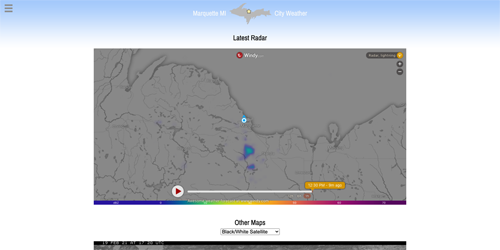
It turns out that Windy.com, a weather enthusiast site I subscribe to that provides all manner of modeled weather data, offers a ready-made widget that will, among other things, display current and past radar conditions. You’ll find this zoomable radar on our Maps page.
For those who want to geek out, click on the “Radar, lightning” link in the upper right. You’ll then see a menu with all sorts of options such as: wind, precip, temps, clouds, waves, pollution, pressure, warnings, etc. It’s a cornucopia of weather info based on the ECMWF (Euro) model.
[Just to clarify, the default radar option displays observed radar returns from NWS Marquette’s NEXRAD installation in Negaunee Township]
Why didn’t I choose to place this on the home page? First, I didn’t want to have to cram it into a given location next to the Almanac. I wanted to provide a full-size map, especially on larger screens. Secondly, I didn’t want to burden the home page with the extra data. It’s about 1 MB for each load of the map. That’s about 20x the bandwidth compared to the old static radar image we used to display from the NWS. It’s important to me that our main page loads very quickly even on a faint internet connection (beach, trails, etc). This allows the home page to focus on what it does best: display observed & forecasted weather for the City of Marquette. You can still access a couple quick, on-demand radar options on the home page.
For those who enjoyed the previous Maps page, I have moved all the other maps directly below the new radar. I chose to default to UW-Madison’s black & white satellite photo b/c it has a smaller footprint (than the GeoColor loop) and offers a lot of detail. Again, I want pages that don’t take forever to load and eat up people’s data plans.
Pro tip: On mobile devices, you can pinch zoom the radar rather than use the + and – buttons. You can easily view the storm situation in the Midwest with just a few swipes or button clicks.
As always, thank you for supporting local weather! Feel free to leave some feedback below.