
The pre-Christmas winter weather event began with two days of moderate snow & relatively calm winds (12/21-22). We were under a “Winter Weather Advisory” during the front side of the area of low pressure. Once the center of the low passed to our south, winds flipped to the northwest, and the blizzard warning began (1 AM 12/23) which lasted until 1 AM 12/25.
While our maximum wind gust of 38 mph on 12/23 was nowhere near a record for our station, that day ended as the windiest day in station history (7.5 years in service) based on sustained winds. The following day was our 4th windiest.
Top wind gusts around town were in the mid to upper 30s. 50+ mph gusts had been forecasted. But, as usual, it takes a lot of energy to achieve speeds above 45 mph in town due to the resistance posed by structures and the amount of land northwest winds have to cross before entering the city.
The Marquette Board of Light & Power only reported one localized outage during the event.
A shortwave disturbance interrupted the lake’s ability to generate snow during the morning hours of the 23rd. By early afternoon, however, dynamics were in place for snowfall to really get going. By Christmas Eve snow was falling at rates greater than 0.5″/hr at times. We ended the 24th with 10.5″ of fresh snowfall.
All in all, we measured 17.4″ of snowfall from 3 PM December 21st through 8 AM Christmas morning. Add to that 4″ of estimated snowfall that went missing from our measurement boards due to excessive winds** and you get the following total:
Event snowfall total: 21.4″
Measurable snowfall ended by dawn on Christmas Day and winds gradually died down by sunset.
——————————————
See the Snow Measurements page for each measurement or visit the Weather History page for daily totals and a complete breakdown of all weather parameters during the storm.
** The estimate of 4″ of missing snow on 12/23 is based on analysis of NWS Advanced Hydrologic Prediction Service. They estimate up to 8 more inches fell from 7 AM 12/23 – 7 AM 12/24 than we recorded (3.3″). But the 4″ estimate is consistent with our visual observations, other measurements we’d taken, radar history and the time period (~9 hours) where snow was falling but blown off our measurement boards (12/23 1 PM – 10:45 PM).
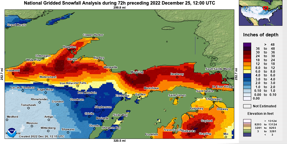
The featured image is courtesy of NOAA’s National Operational Hydrologic Remote Sensing Center. Keep in mind that it only goes back to 7 AM on the 22nd. A little over 2″ fell before this point on the 21st and overnight the 22nd.
How much snow was credited to the city of Marquette? I measured almost the same as NWS in Marquette township about 1.5 miles from Neg two line. Appreciate any feedback. Thanks
Carl, officially the Marquette COOP station measured 12.4″ over the period of the 21st through the 25th. However, they too had issues on the 23rd/24th and recorded no snowfall on the morning of the 24th (which covers the time period from 8 AM 12/23 – 8 AM 12/24). They did, however, collect 0.53″ of liquid precip during that time in their standard rain gauge. If you multiply that amount by 15 (a conservative snow-to-liquid ratio) then you get 8″ of snow. So that would put them at 20.4″ for a storm total.
We measured 21.4″ here at 735′ elevation. What’s your elevation?