Blog

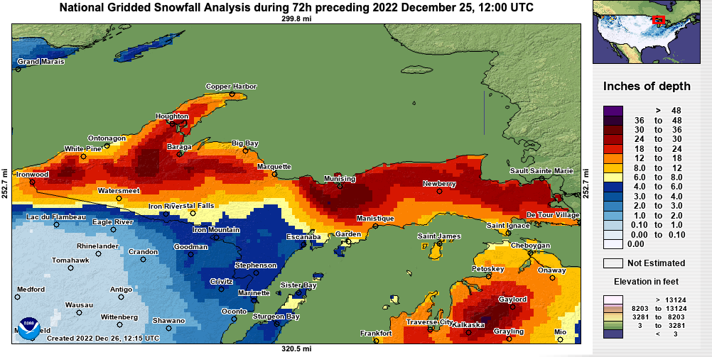
The Great Pre-Christmas Blizzard of ’22

The pre-Christmas winter weather event began with two days of moderate snow & relatively calm winds (12/21-22). We were under a “Winter Weather Advisory” during the front side of the area of low pressure. Once the center of the low passed to our south, winds flipped to the northwest, and the blizzard warning began (1 AM 12/23) which lasted until 1 AM 12/25.

While our maximum wind gust of 38 mph on 12/23 was nowhere near a record for our station, that day ended as the windiest day in station history (7.5 years in service) based on sustained winds. The following day was our 4th windiest.

Continue reading “The Great Pre-Christmas Blizzard of ’22”

Winter Storm Wrap-up (2/21/22 – 2/23/22)

After 50+ hours of snowfall, the sun finally appeared this afternoon!

This was a storm for the record books on parts of the Lake Superior Plateau (Negaunee area) where they received over 37″!

Down closer to the lake, we measured 18.3″ between 8 AM Monday the 21st and 5 PM Wednesday the 23rd. Meanwhile, the city’s official station recorded 13.5″ from 8 AM Monday to 8 AM Wednesday (we only recorded an additional 0.6″ after 7 AM). No daily or monthly records appear to have been set in Marquette.

Yes, “Twosday” (2/22/22) was by far the snowiest day of any February in our 5 years of measuring snow. In fact, that day ties 12/01/2019 for the snowiest one-day total on our record books. However, the December day produced 1.44″ of melted snow. Whereas yesterday the snow only melted down to 0.65″. Much lighter snow this time around! You can thank the colder temps for that — something you might have thought you’d never do.

It appears this was a very elevation-dependent storm system with Big Bay recording 20″ and similar numbers as ours from a station in Harvey close to the lake. Further up in Trowbridge (elevation: ~1000′), we see totals approaching 2 feet. That all makes sense since the lake definitely played a big part in the storm. Lake-effect (or enhanced) snowfall is quite subject to forces of elevation. For reference, we are 100′ higher than the official COOP station in Marquette, which partially explains our higher snowfall totals (generally, in fact).

Not for nothing, the website quadrupled it’s normal traffic on the 23rd! Google really likes our snowfall measurements and weather history pages. Many thanks to our dedicated visitors who encourage us to keep marching out into the wind-driven snow to take those measurements all winter long!

Winter Storm “Atticus” Wrap-up

Beginning around 9 PM on Friday December 10th and lasting through about 2 PM on Saturday the 11th, an area of deep low pressure tracking near the Straits of Mackinac resulted in significant snowfall at our station near downtown Marquette. Overall, we measured 7.8″ of heavy, wet snow, although up to an additional inch may have fallen and gone unrecorded due to slightly above freezing temperatures, wind and sunshine. Our storm total was similar to a nearby report in Trowbridge of 8.5″.

Our highest wind gust during that period was 37 mph in the 11 AM hour. The 11th was the windiest day of the month so far in terms of sustained winds.

Our only real impact was time spent removing snow from the property afterward. No power outages were experienced during the storm.

For a detailed hourly breakdown, please check out our Weather History page and select the dates above (Dec 10-11, 2021). We don’t offer hourly precipitation data, but all other parameters like wind, temperature, and pressure will be available.

Live Blog (April 12-13, 2020)

NOTE: Entries are in reverse chronological order. This page does not automatically update.

  • 4/13/20 3:50 PM
    Winds continue drifting westward, shutting down lake-effect snow production. We’ve had no measurable snow since 12 PM. Humidity has dropped to around 65%. This should spell the end of our snow storm. I see that the National Weather Service has pulled down the Winter Storm Warning that was supposed to last through tomorrow morning. Gusty winds should subside over time, especially after sunset. But do mind the lakeshore flood warning and stay clear of Lake Superior as it takes some time to settle down after winds abate. Anyway, that ought to do it for our live blog. Again, our storm total was 17.2″ as measured 1 block north of the Jacobetti Veteran’s Home near downtown Marquette.
  • 4/13/20 2:45 PM
    Some light flakes continue to fly but nothing significant. The focus now is on the wind. Even as the trough of low pressure crosses into Quebec, it continues to deepen, drawing air from areas of higher pressure, such as Marquette, toward it. How big is this system? Well, it has 5 frontal boundaries extending from it, including 2 cold fronts stretching down into the Gulf of Mexico!
  • 4/13/20 1:15 PM
    After declining for about 4 hours, winds have kicked back up in the last hour as the surface low exits the region. Gusts nearing 35 mph have been observed here. Snowfall has tapered off to light snow showers as winds have turned solidly to the northwest.
  • 4/13/20 12:20 PM
    Light snowfall. Latest measurement (10 AM – 12 PM): 2.1″. Event total: 17.2″
  • 4/13/20 10:00 AM
    Moderate snowfall. Visibility 1/4 – 1/2 mile. Snowfall measurement (7 AM – 10 AM): 1.2″. Event total: 15.1″
  • 4/13/20 9:30 AM
    Some lake-enhanced snowfall could set up soon, lasting at least into the early afternoon hours. Conditions are somewhat marginal, so not expecting too much additional if the lake gets involved. Knock on wood because this is spring in the U.P. and Mother Nature likes to take a shot at us this time of year. Currently less than 1/4 mile visibility due to blowing snow.
  • 4/13/20 8:55 AM
    Looks like we’ve bottomed out in surface pressure. Our gauge recorded 998.7 mb (29.49″) MSLP at ~ 7 AM EDT. The center of the low is located near Sault Saint Marie. It should slowly march NE into Quebec this afternoon. We should be nearing the top of the mountain in terms of winds within the next hour or two (if we haven’t arrived already).
  • 4/13/20 8:25 AM
    Moderate snowfall continues. Visibility is generally 1/4 – 1/2 mile but localized blowing snow creates near whiteout conditions at times. Gusty northerly winds (30-35 mph gusts) continue to buffet the city.
  • 4/13/20 7:30 AM
    Winds continue to ramp up over the last several hours. The peak wind gust measured so far here is 34 mph but 40 mph does not seem not out of reach by later this morning. Fortunately, the moderate to strong winds throughout this storm have kept power lines free of snow.
  • 4/13/20 7:00 AM
    Moderate snowfall. 1/4 – 1/2 mile visibility. Snowfall measurement (9 PM – 7 AM): 8.2″. Event total: 13.9″
  • 4/12/20 9:00 PM
    Moderate snowfall. 1/4 – 1/2 mile visibility. Snowfall measurement (6 – 9 PM): 3.6″. Event total: 5.7″
  • 4/12/20 7:45 PM
    Heavy snowfall continues. Visibility between 1/8th – 1/4 mile. Next snowfall measurement at approximately 9 PM.
  • 4/12/20 6:05 PM
    Visibility has dropped to approximately 1/8 mile due to heavy snowfall. 2.1″ measured so far.
  • 4/12/20 5:30 PM
    Snow is beginning to stick to roadways too now. Visibility is just over 1/4 mile.
  • 4/12/20 4:05 PM
    Snow is beginning to stick to grassy areas around our property now. Cement is wet but free of snow.
  • 4/12/20 3:25 PM
    Initial snowfall this afternoon has been melting on contact due to the relatively warm ground, but temperatures have been falling over the past couple hours.
  • 4/12/20 9:00 AM
    Expect the snow to start flying by mid afternoon. Heaviest snowfall after 8 PM. Winds should stay light to moderate until daybreak Monday.  Winds will build after that point reaching a peak in the afternoon. Blizzard-like conditions are likely as it will be snowing all day Monday. As per usual, I will report periodic measurements & observations here throughout the event. Keep checking back.

Live Blog (January 18-20, 2020)

  • 1/20 08:00 AM:
    Skies are finally clear. The moon is up in the SE sky. Snowfall has ceased! Picked up an additional 0.2″ overnight to bring our final storm total to 11.3″.
  • 1/19 10:15 PM:
    The dry air that was supposed to enter the area by midday never happened. Instead, we’ve seen a steady stream of light, lake-effect snow. 0.4″ has fallen today and continues falling at this hour. This brings our storm total to 11.1″.
  • 1/19 2:50 PM:
    Light, intermittent snow showers continue coming in off Lake Superior, but, so far, it hasn’t been accumulating. The weekend storm total remains 10.7″ since Friday night (1/17). If you’re thinking of waiting until the holiday tomorrow to clear snow, that’s not a bad plan. Winds will be lighter, and the sun should come out.
  • 1/19 11:00 AM:
    Only a trace of additional snow since 7:30 AM. Snowfall is now intermittent with peaks of blue skies and sunshine. Looks like the storm is finally wrapping up.
  • 1/19 10:00 AM:
    Seeing some localized blowing snow. Gusts have been around 20 mph this morning.
  • 1/19 7:45 AM:
    2.4″ of fresh snow fell between 11:15 PM last night and 7:30 AM. Storm total is now up to 10.7″. Light to moderate snowfall continues this morning. Snow should end by noon but winds will remain brisk.
  • 1/18 11:30 PM:
    Another 1″ of snow has fallen in the last 3 hours bringing our storm total to 8.3″. Models show another 1″ mostly falling before daybreak. Wouldn’t be surprised if that turns into 2+” by 8 AM.
  • 1/18 8:20 PM:
    We picked up 1.3″ of additional snowfall from 2 PM to 8 PM. Event total so far: 7.3″. Meanwhile, lake-effect snow showers are underway and should intensify as the night wears on. I’ll take one more measurement before midnight.
  • 1/18 4:40 PM:
    Pressure is now rising. Winds directions are wobbling from north to northwest. Winds should stabilize to northerly eventually. There may be a bit of a lull for a few hours while lake-effect snowfall conditions optimize (faster winds, cooler temps, etc). Next snow measurement: 8 PM.
  • 1/18 2:15 PM:
    Additional 0.6″ measured at 2:00 PM bringing storm total to 6.0″. Expecting pressure to bottom out in the next couple hours. Winds will turn to the north and increase in speed as lake-effect snow commences. Could see heavy snowfall again this evening and/or overnight.
  • 1/18 12:10 PM:
    Snuck outside at noon for a preliminary measurement following heavy snowfall. Recorded an additional 3.7″ since 8 AM. That brings the storm total to 5.4″.
  • 1/18 10:35 AM:
    A heavy band of snowfall has dropped visibility to 1/4 mile. Meanwhile, wind speeds have been trending down all morning. Expect a directional change this afternoon. That’s when Lake Superior starts to get involved.
  • 1/18 8:00 AM:
    1.7″ measured since snow started flying last night. It’s fairly lightweight & shouldn’t be too difficult to shovel. I’ll take another measurement at 2 PM.
Back to Top
Theme:

(Auto night: 11:07 PM - 4:28 AM)