Blog

2024 Air Quality Index (AQI) Update

2024 AQI Revisions
Image courtesy of IQAir

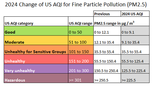
On May 6th the U.S. Environmental Protection Agency rolled out a change to the Air Quality Index (see table above). We didn’t receive notification of this until yesterday. These modifications are now live on the website — both in current conditions and in the weather history tables effective July 19, 2024.

Keep in mind, we apply an EPA correction factor to the AQI reading. If you visit other air quality websites or apps, the readings may seem incorrect if, by default, they report raw AQI. The most accurate way to compare our sensor readings to others nearby is to visit https://fire.airnow.gov/. Click the search icon, type in “Marquette, MI” and hit enter.

Why do we correct the AQI? Because researchers at the EPA discovered that by applying an algorithm to our “low-cost” (~$400) PurpleAir sensor its readings better approximate the higher-cost, more accurate government sensor readings. Experiments were conducted within the context of wildfire smoke pollution — the thing people are most concerned about here.

New Station All-Time High

On Labor Day (9/4/23) our station recorded a maximum temperature of 95.7° which eclipsed our previous all-time high of 95.2° on June 6, 2021. We have been (unofficially) recording weather at this location since July 2015.

Our maximum heat index on Monday 9/4 was 102°. The dewpoint topped out at 72°. It was a very muggy day by Upper Michigan standards (dewpoints typically in the 40s/50s in early September).

Got a Little Rain Last Night…

Last night around 9 PM EDT, we experienced a deluge of rain during a severe thunderstorm. Our automatic tipping spoon recorded the second highest rain rate in the 8 years we’ve been online (10.7″/hr). Overall, we picked up just over 1.5″ of rain in half an hour with about 1″ falling in the first 15 minutes of the storm.

We clocked a 37 mph wind gust during the storm. However, each wind measurement must last up to 2.5 seconds to be recorded by our system. It’s quite possible higher, shorter-lived winds were present during that storm as radar had indicated up to 60 mph gusts according to the severe thunderstorm alert issued by the National Weather Service.

There was lightning aplenty but no hail. We got quite the hail storm on Saturday July 22nd. The entire property was coated with pea size pellets.

Marquette is running WELL above normal for July rainfall. So far 4.89″ has been recorded by our automatic gauge (which is checked against a manual gauge daily). Marquette’s 30-year normal rainfall for July is 2.77″.

Incidentally, the third highest rain rate in our history (9.75″/hr) was recorded less than two weeks ago on July 15th when we picked up 0.64″ for the day.

Hazardous AQI Due to Neighbor Burning Trash

Just a note…

If you are curious why we experienced an AQI (Air Quality Index) over 400 during the lunch hour it’s because my neighbor was burning trash. Otherwise, the air quality has been good to moderate today.

Researchers sometimes come to the site and examine the Weather History for a given day — sometimes years afterward — and might furrow their brow at such an extreme outlier not recorded by any other nearby station. Hopefully they find this blog post.

The Great Pre-Christmas Blizzard of ’22

The pre-Christmas winter weather event began with two days of moderate snow & relatively calm winds (12/21-22). We were under a “Winter Weather Advisory” during the front side of the area of low pressure. Once the center of the low passed to our south, winds flipped to the northwest, and the blizzard warning began (1 AM 12/23) which lasted until 1 AM 12/25.

While our maximum wind gust of 38 mph on 12/23 was nowhere near a record for our station, that day ended as the windiest day in station history (7.5 years in service) based on sustained winds. The following day was our 4th windiest.

Continue reading “The Great Pre-Christmas Blizzard of ’22”

Back to Top
Theme:

(Auto night: 10:48 PM - 5:04 AM)