Blog

A New Interactive Radar Map

New Maps PageLast December we had to remove the radar imagery that appeared on the home page (for most devices). This was due to the recent overhaul of radar data by the National Weather Service.

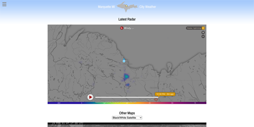
Since then I’ve been looking for a replacement radar interface that was free and didn’t track end users.

It turns out that Windy.com, a weather enthusiast site I subscribe to that provides all manner of modeled weather data, offers a ready-made widget that will, among other things, display current and past radar conditions. You’ll find this zoomable radar on our Maps page.

Continue reading “A New Interactive Radar Map”

Jan ’21: Warm & Dry & A Somewhat Clear Sky

Marquette just recorded its least snowy January on record (1857 – present)! The official station at the Water Treatment plant recorded a mere 3.5″. Normally, we receive almost 30″.

Melting that snow and combining it with whatever ice and rain also fell, amounted only to 0.77″. That’s less than half the 30 year normal amount of 1.83″.

Also, the mean monthly temperature of 24.7° in January ties for 8th on the list of all time warmest with 1878.

Here at our station near the Jacobetti Home for Veterans, we recorded 10.4″ of snowfall (0.72″ of liquid) in January. Whereas the last 3 winters we averaged 29.4″.

Our station’s monthly mean temperature (as measured from 8 AM to 8 AM and rounded to whole numbers) was 23.9°. That’s +5.5° compared to our station’s normal.

Continue reading “Jan ’21: Warm & Dry & A Somewhat Clear Sky”

Radar Changes

The National Weather Service has changed the method radar imagery is delivered. Unfortunately, that means, for the indefinite future, we will not be able to feature a static radar image on the home page.

For the time being, we offer two radar options: Weather Underground’s animated radar and Dark Sky’s static radar. These are available in the “Enhanced Radar” selector immediately beneath the quick forecast icons. There may come a time when these alternatives also cease to function.

We are searching out other possibilities for radar imagery. Please bear with us as this is beyond our control. Thank you!

Record Cold in Marquette

Following 2 days of highly unusual lake-effect snow (8″ recorded at our station), Marquette saw it’s coldest October 27th in recorded history. NWS Marquette has confirmed that the low of 20° this morning set at the COOP station near the lakefront broke the old record of 22° set back in 1887.

October is running about 5° below normal. As of the morning of 27th, this is the 19th coldest October on record (since 1857). Finishing in the top 20 certainly appears doable if the forecast holds.

Overall, we’ve had a cool (meteorological) autumn so far as September was also a couple degrees below normal.

We’ll just have to see what the winter brings. It could all turn on a dime next month. But at least the weather’s never boring in the U.P.!

New Rain Calibration Active

You may have noticed that at times rainfall totals in the Almanac section or History page suddenly shift, usually downward. That’s because the automatic rain gauge runs a little wet. Oftentimes, I circle back and correct the amount with what I’ve measured in the manual gauge (~ 6′ away and 3′ lower).

Well, through the wonders of technology (a.k.a. Microsoft Excel), I was able to finally calculate the error and program a correction for it. Over the last 12″ of rainfall, it’s a pretty consistent 4-8% overage. It averages out to +6.5%. So I am subtracting that from realtime readings now. I’ll keep an eye on it to see if it changes over time.

For small events, it may not have any effect whatsoever. But in larger rain storms, it should allow for fewer corrections and, thus, less confusion.

Back to Top
Theme:

(Auto night: 10:18 PM - 5:14 AM)